1 EAGLETON NOTES: Isle of Harris

.

.
Showing posts with label Isle of Harris. Show all posts

Tuesday, 5 December 2017

Harris on a Winter Monday

My almost-lifelong friend, Mo, from Canada and I drove south to Harris yesterday. It is a drive with views of landscapes varying from wild areas of 'moonscape' rock bare of habitation and much in the way of vegetation to world-class beaches stretching for miles. We started in the late morning with coffee and Christmas cake at the Harris Distillery in Tarbert. It was a good job that we did because we did not find another single place open to get any food or drink on the entire South Harris. Fortunately there is a good scattering of well-maintained public toilet facilities.

The weather varied between dreich, heavy mist and rain to occasional flashes of blue sky and sun: The Outer Hebrides at it's varied winter best.

I only took a few photos but they will give you a flavour of our trip.

The East side of South Harris south of Licasto
A rare sunny moment turning the hillside golden on the East Side near Geocrab
On the West looking North to Northton and Northton Sands

Friday, 9 October 2015

Safari Day 4: Harris

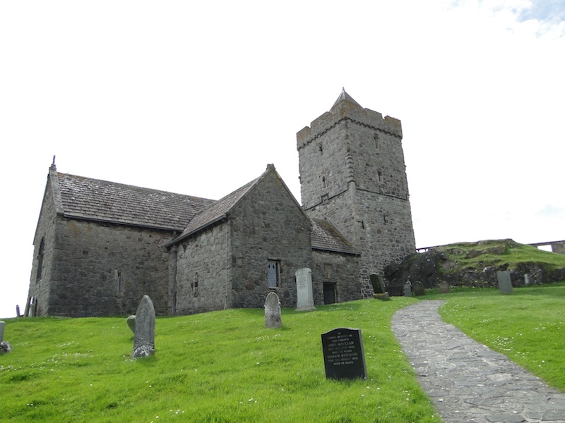
Day 4 of our safari saw Pauline and I travel down to Harris. For some reason I took fewer photos than I usually do but I know that Pauline tool lots so I will simply show you a few of St Clement's Church in Rodel at the southern point of the Island. For those who would like to know more about the church the Historic Scotland website may be of interest.


Thursday, 4 December 2014

Life, An Update

On Tuesday (is it really Thursday already?) we ('we' being Anna - a friend who had been staying - and I) drove down from Eagleton to Bishopbriggs.  We came via Skye and the Western Highlands and it was a beautiful drive.  Until, that is, night closed in as we left Fort William.  For me it was a foretaste of something I've not experienced since 2005: driving with temperatures around zero and the threat of ice on the roads.  The car is getting shod with winter tyres tomorrow.

It's great being down here are catching up with folk, shopping, going to a concert and the theatre and so on.  In theory I should have just as much time for Blogland but I've hardly read a blog this week.  I also miss the Big Skies which you just don't get in towns and cities. This is the sunrise a few days before I left: 


As we left the little township of Tarbert on Harris to cross to Skye I left a little bit (quite a lot actually) of 'me' there.

Boarding the ferry MV Hebridean Isles
Tarbert is on an isthmus between North and South Harris 
The barren landscape of Harris made even more rich and brown in the low sun of winter. 
The splendid bridge between the mainland of Harris and the small island of Scalpay

Saturday, 30 August 2014

My Last Climb of The Clisham

On a day in March 2004 Gaz and I had planned to climb The Clisham: the highest mountain in the Outer Hebrides, at 799 metres (2,621 ft) the archipelago's only Corbett.   Not long previously we had climbed Ben Lomond: at 974 metres (3,196 ft) and situated on the eastern shore of Loch Lomond, it is the most southerly of the Munros.   My photos, however, show the former on one of the most glorious of days.  


For Gaz, who the previous week had climbed Mont Blanc, this was just a  stroll in the park. 


Tuesday, 26 August 2014

A Visitor From New Zealand

On Wednesday a friend from New Zealand who is on a gap year teaching in Germany came for visit to Lewis.  The weather's been varied but it hasn't stopped James from exploring the Island's tourist spots with me and also going tramping on his own and exploring lesser known spots.  Today with the sun shining out of a clear blue sky and the temperature quite respectable out of the wind we went off to do the tourist trail in Harris.    I should, at this stage explain that nowhere, absolutely nowhere, is out of the wind in Harris and the wind was cold, very cold.  That didn't stop James from going for a swim.

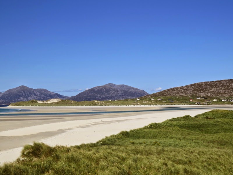
No one can say that we don't have beaches and scenery here to match, or better, the rest of the world. What I do have to admit is that we don't have the hot, sunny weather that makes other beaches full of people and ours rather less so.

James using Google Photo Sphere (of which more in another post)

Very tempted!  I last climbed The Clisham in 2004 with Gaz
At Horgabost with Taransay Island in the background.
...and what is James doing standing in the water?  Using Google Photo Sphere again
Horgabost looking north
Enjoying the (very cool) water 
At Luskentyre
...can't wait to get to the water
That's James...the wee dot in the centre of the photo.  It's a big beach. 
....a huge one in fact.
and looking south from the same spot towards the Horgabost beach.

Thursday, 4 October 2012

Eagles Galore

Viv had never seen an eagle in its natural surroundings.  Today she saw four, perhaps five.  We went to Harris.  The first two golden eagles were soaring very high above the hills on the Lewis and Harris border of Loch Seaforth (so high, in fact that at times I lost sight of them), then two were being chased by hooded crows a little further on over the climb towards the Clisham and the last possible sighting was down at the Southern tip of Harris at Lingerbay.  OK I promise not to post any more eagles until I have something really spectacular to show you.


Golden Eagle being chased by two hooded crows

Tuesday, 23 August 2011

We Have Sheep Too

It's not just the occasional cattle that block the road.  Sometimes it's sheep:

Shepherding at Rodel, Isle of Harris

Monday, 22 August 2011

Harris Roads

The road down the East side of the Isle of Harris is tortuous because the coastline is a mass of small inlets with lots of rocky outcrops and very little flat land.  The area is sparsely populated and the road is not only tortuous but also narrow with passing places and plenty of blind bends...and other hazards:

An impasse
An impressive piece of beef capable of making a mess of the car if he got upset

We Went To Harris Today

Unfortunately CJ's reputation for bringing the sun has been tarnished this visit and the weather's not been sunny enough for photos recently for us to make the trip down to Harris.  Until today.  So we were out early and in Tarbert for coffee a few minutes after 10am.  I've little doubt that as CJ took over a thousand photos (so he reckons he'll have a few worth showing) that you'll be able to follow our journey on his Hebridean Blog.  I'll probably do a few posts too but first I thought I'd show you one of our beautiful Harris beaches with Cj doing what he spends a lot of time doing:

Horgabost, Isle of Harris (with a little blob near the water's edge)
The little blob using telephoto - I'm using the telephoto, not the little blob!

Thursday, 23 June 2011

Thankful Thursday

I may well have posted these photos before.  Then again I may not have done so.  Unfortunately memory is not one of my strong points.  In fact I can't even remember what my strong points are or were.  However as this is about being thankful I will explain the relevance of the two photos.  The mountain or hill is The Clisham.  It's a Corbett at 799 m or 2621 ft.  This photo was taken in 2004 which is the last time I climbed anything significant.  Recently I have been feeling a bit sad that I am unlikely ever to be able to climb such a hill again.  Actually I probably could climb up it with some difficulty but I would be unlikely to be able to get down again.  Why?  Well if I tell you that I sometimes get comments on the noise my knee sometimes makes when I walk across a room you'll get the picture.  This is not a 'poor me' post.  I can get on perfectly well with my knee as it is and I'm not in significant pain most of the time.  But it does have its limitations.

However this is a Thankful Thursday post and looking back at all I've done and all the hills I've walked I am very thankful that I had those experiences.  There are a great many people who have never been able to walk at all; many who have been injured and cannot walk now; many who are just getting older.

Yes.  I am very thankful.

Gaz, laid back as ever, just ready for a stroll up The Clisham having climbed Mont Blanc a few weeks previously.
On top of The Clishsm

Wednesday, 25 May 2011

St Clements Church, Rodel

I mentioned a few weeks ago that I would do another post on Rodel Church.  In fact I shall do several.  Here is the first: of the 1528 tomb of Alasdair Crotach MacLeod, 8th Chief of MacLeod.  I shall keep the text brief because there is lots of information on this important 15th century Isle of Harris landmark notably Wikipedia, Undiscovered Scotland (a complete misnomer in this case because Rodel Church is very discovered and essential visiting by any tourist on Harris) and Leverburgh.co.uk .

1528 tomb of Alasdair Crotach MacLeod, 8th Chief of MacLeod,
The Holy Trinity
An angel spreads insense from a censer
A Highland Galley under sail - part of the measure of a Chieftain's power

Sunday, 13 September 2009

Harris Township and Old House

My last two postings have been devoid of photographs so I thought that I would redress the balance and post two photos that I took a few weeks ago when I went to the Isle of Harris. The first one gives an idea of the remote and sparse nature of the rural settlements in the Islands of the Outer Hebrides.  It is the township of Maaruig.


Tuesday, 1 September 2009

Rhenigidale, Isle of Harris

Rhenigidale is a township (village or hamlet) on the Isle of Harris in the Outer Hebrides of Scotland. It had 7 houses plus an almost completed new one and not many more of a population. Not all the houses are occupied permanently. Until 1987 the township had no road and the only access was by footpath from Urgha 3.26 miles away near Tarbert or by sea. The landing place for boats was a rock face roughly turned into a crude wharf or jetty. It's still used today but mainly for servicing fish farms in the area. In 1987 a road was built connecting the township to the main Tarbert to Stornoway Road at Maaruig; a distance of about about 5 miles of which nearly 4 miles was completely new road over bogs and through solid Lewisian Gneiss some of the oldest rock on earth. The cost at that time was £750,000.

Anna and I took a trip there last week. The journey itself took about 10 minutes. Quite a few hours less than the first time I visited Rhenigidale on foot in a gale and pouring rain.

Looking down from the plateau to the main Stornoway to Tarbert road

Down from the plateau to Rhenigidale (which is just around the corner)

The old footpath from Rhenigidale to Urgha and Tarbert

Nestled into the hills

The jetty is to the left of the moored boat

The Gatliffe Trust Youth Hostel - basic but as I discovered many years ago when I stayed there before there was a road - very welcome after a long walk through driving wind and rain.

The school is on the left. By the time the road was made there was one pupil - that of the schoolteacher. The house is that of the principal campaigner for the road, Kenny Mackay, who was married to the schoolteacher.